Drone Building Surveys & Roof Inspections
Safe and detailed aerial property surveying by qualified pilots, photographers, and surveyors, serving Hampshire, Sussex, and the rest of the UK
Decades of property surveying expertise, aerial and ground photography experience, Ministry of Defence approved drones and extensive knowledge of building insurance claims make Solent Sky Services™ the go-to CAA-approved drone company for UAV building surveys, roof inspections, and 2D or 3D site mapping.
We work with property owners, architects, estate agents, chartered surveyors, local councils, insurance firms, and religious organisations to create and explain drone building surveys, with commercially-approved pilots capturing millimetres-accurate images and our in-house property expert annotating the outcomes.

Easy to analyse: specialist surveying software and mapping
Aerial property inspection app Scopito sends the visuals we capture to our in-house surveyor in real-time, so as our pilots fly, SSS HQ gets to work on processing, annotating, and delivering geotagged surveys. We can cross-reference our shots with existing map data, invite your surveyors to make their own highlights, and, where necessary, provide a full 3D model of your premises. When you book us for multiple inspections, you’ll also be able to compare older surveys to recent ones!

Hard to reach: aerial property inspections. Larger drones with special permissions
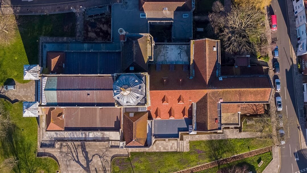
Skip the scaffolding! Drone roof surveys will provide you with sharp HDR pictures and 4K or 6K videos of your property. Our industry-leading image resolution and aerial camera optics capture visuals that are crisp down to millimetres and perfectly-exposed from the brightest tiles to the darkest gutters. With minimal disruption to your property’s everyday use, we’ll quickly and safely identify structural issues with roofs, chimneys, walls, gutters, parapets, and gables.

Hard to fly: camera pole roof surveys and tiny drones
The absolute quickest and lowest-cost option for pseudo-aerial surveys: tiny drones or telescopic pole-mounted cameras! While this grounded approach to roof inspections isn’t quite as in-depth as taking the drone route, the results more than suffice for professional reports and recommendations. We recommend pole cameras for dense urban spaces where conditions aren’t ideal for safe flights, or for projects which call for a faster turnaround than average — they need fewer permissions, and can often be booked and completed on the same day.
Contact us about our drone surveys and aerial inspections
Need a quote for a drone inspection, want to book in a webinar or find out more about our surveys? Fill out the form below and we will be in touch.
FPV Drone Film Projects
Parker Torrington Ltd.: Surveying Storm Damage with Drones
Gosport-based chartered surveying practice Parker Torrington approached Solent Sky Services following the stormy weather that shook the south coast of England early in 2020.
Scaffolding and similar surveying methods would have been cumbersome, costly, time-consuming, and comparatively unsafe — especially for this particular Parker Torrington property, which has a peculiarly-shaped roof.
Our drone roof inspection, meanwhile, was booked and completed in the same week! We captured photos of every area of the roof, providing an unparalleled resource for identifying storm damage and planning repairs.
On top of our usual safety measures and pre-flight assessments, this job called for heightened ‘operational safety’ permissions, due to challenging circumstances around take-off and landing distances.
Fortunately, as we’re a reputable drone company known for our professional precautions, we were able to quickly and cost-effectively plan flights with these heightened legal permissions!

Qualified Professional drone Pilots
You’ll be working with legally-approved professional pilots. We hold operational authorisation, granted to us by the Civil Aviation Authority (CAA), for legal FPV flying! We’re also a member of Drone Safe Register.

National Drone Coverage
We work all over the UK — even at sea! Our software can upload imagery from one end of the country to be instantly inspected by our surveyors at another end of the country.

Residential & Commercial
We’ve the knowledge, contacts, and professionalism to organize legal flights in public and private spaces, and to inform all interested parties.

Serious About Safety
Risk assessments, pre-flight plans, and specialist PPE: we ensure every shoot is safe, and closely adhere to the special rules that apply to FPV flights.

2D & 3D Mapping
We can survey, inspect, and map existing and developing sites, both natural and manmade, in top-down 2D and fully-maneuverable 3D.

Visual Annotations
2D and 3D surveys can be enriched with informative highlights, lines, measurements, and links to ground photos and videos.

Attention to Detail
Our surveys are informed by decades of property inspection experience — we notice the small details that make a big difference.

Ground Backup
Every good pilot has a contingency plan! If flights can’t safely continue, we’ll use telescopic camera poles to conduct roof surveys.

Format Friendly
Every client has different software and workflows. We’ll deliver results in formats that are compatible with the IT systems you use.

Team Training
If a project calls for specialist software, we can train you and your team on how to use it efficiently, either on-site or remotely.

Property Professionals
As well as better-informing our aerial inspections, we channel our property surveying expertise into detailed reports to complement visuals.

Multi-Date Deals
We offer multi-day packages for longer-term projects. Need surveys before and after big changes? Book ahead in bulk with us!
Drone Survey Projects

Oyster Quay residence: notifying the hundreds
Conducting drone surveys for private corporate spaces – especially ones that are only open during the working week! — can sometimes prove quite straightforward during the planning phase. Large residential properties, on the other hand, don’t have windows of vacancy; by their very nature, they’re always at or near capacity. When Oyster Quay hired us to carry out a general inspection of their roofs, we worked with them to ensure every tenant on their premises was notified of our flights well in advance.
Informing residents isn’t just a legal requirement or a respectable thing to do — it also helps build rapport with people who might typically be wary of drones, but who instead appreciate the forethought behind property-wide notices. In the case of Oyster Quay, the rooftop spot we identified as being the prime take-off point for our building survey was the garden area of one of the penthouse tenants!
A few days after our letters went out to everyone living at Oyster Quay, we met the tenants to ask whether they’d allow us to access their garden for the flights. They explained that our notices had quelled any apprehension they might have had, and that they were excited to help us! That’s the kind of trust every drone pilot should aim to earn.

Newhaven Port Authority: harbour master partnership
Newhaven in East Sussex is a channel ferry port, and with every part of the village being in such close proximity to the bustling waters, contacting the harbour master at the Newhaven Port Authority is always a must.
After years of communicating with harbour masters along the UK’s coastlines to gain permissions for aerial marine photography projects, we’ve sadly realised that they witness hundreds of illegal drone flights every year — so whenever they get a call from a pilot preparing professional flight plans, they’re always so relieved and eager to co-operate!
When we contacted the port authority in Newhaven to confirm we were clear for take-off, the harbour master asked whether we’d be able to shoot pictures of the roofs of their warehouses, which weren’t too far away from where we were working for a client. They needed imagery for an ongoing insurance claim, and we obliged — after writing up another batch of flight plans, of course! The timing couldn’t have been more perfect for the Newhaven Port Authority.
While many pilots quietly dismiss permissions as a time-consuming frivolity, we see it as one of the easiest and most natural ways to procure two new jobs for every one job we complete!

Surveys on a stick! An alternative approach to roof surveys
A property owner in Portsmouth approached us early in 2020 after storms hit the city. She hired us to survey six sites, and, to help keep costs as low as possible, we used specialist cameras mounted on telescopic poles! While not as comprehensive or flexible as drone roof inspections, pole-mounted cameras are a viable and effective alternative for property surveys. We documented the client’s six properties in a single day, and she was elated with the quality of the pictures she received!
Scopito: turning inspections into insights

We use bespoke drone surveying software Scopito to upload mapped sites and properties the moment we land, so our surveyors back at SSS HQ can start annotating and geotagging photos in an instant — even if we’re on the other side of the UK!

Categorised Notices
Our annotations are sorted onto different layers, so you can quickly drill down into the most vital data. Need a starting point for repairs and maintenance? Markers for our most urgent recommendations can be shown, and primarily cosmetic issues hidden.

When & Where?
We plot our aerial survey photography on existing map data for fast cross-referencing with your own property plans. Booked us for multiple dates? Accessing and comparing a history of inspections takes seconds — great for analysing repairs and developments.
Artificial Intelligence
Scopito’s developers share our forward-thinking love for evolving drone tech. At the heart of the software is an AI engine which, as we and other users feed more info into the app, gets more and more accurate with its automatic identification of maintenance requirements.
Drone Surveying CPD & Training

Our continuing professional development (CPD) sessions help civil engineers, property surveyors, and estate managers integrate drone inspections into their repertoire.
We’re CAA certified, a trusted supplier for the Ministry of Defence, and familiar with working in high-security spaces, including the British Transport Police headquarters and HM Prison Pentonville.
The ever-growing list of commercial drone applications that we cover in our CPD training sessions for the surveying, civil engineering, and construction industries include:
2D and 3D UAV site mapping
Structural maintenance inspecting and reporting
Infrastructure surveying and monitoring
Emergency assessment of environmental events
Construction vehicle access route mapping
Inspection of mechanical structures, e.g. cranes
Monitoring of utility structures, e.g. scaffolding
360º photography for immersive remote surveying
Live video feeds for real-time inspections
Best use guidance for drones and UAV accessories
Construction updates for stakeholders and press
Residential inspections: roofs, aerials and masts, chimneys, spouts, walls, cornices, gutters, flashing, parapets, tiles and shingle, gables, and more
Inspections for listed buildings, heritage monuments, and historic structures
Public asset inspections: thoroughfares, bridges, tunnels, underground access points, dams, reservoirs, wind farms, culverts, viaducts, overhead wires, etc.
Transport inspections: pavements, roads, motorways, railway lines, transit hubs, airfields and runways, storage facilities, bike lanes and storage, et al
Procuring topographic and volumetric data
Cinematic drone photography for marketing purposes
Managing, geotagging, and annotating surveys
Safety, legalities, and flight planning
Kind words from our clients
“Mike did a fantastic job for me with his drone, taking incredible property photos. He is very professional and knowledgeable. I would recommend Mike 100% and will use again for future work. Many thanks for your help.”
“Found Solent Sky Services via an internet search for drone surveys as we were concerned that there were some slipped tiles on our roof, and the only other option was to hire scaffold. Mike responded to our initial request very promptly, and surprisingly, said he could complete the job the next day (a Sunday) as long as relevant permissions were available. Arriving at time suggested, Mike confirmed with us the exact areas of concern, informed us what the plan was, checked we had informed neighbours (purely for privacy) and prepared to launch a small drone. 30 minutes later, the entire roof had been surveyed with Mike explaining exactly what he was doing all the time. This morning, we have reviewed high-quality 72 images and videos of very good clarity, and that cover 100% of our roof (and a couple of wider angle views for reference). Solent Sky Services have provided us a very rapid, professional and good value service that has given us confidence that if any work is required, we can use these images as references; something we would not have got using scaffolding. Thoroughly recommend.”
“We appointed Solent Sky Services to inspect a roof to a commercial storage unit which was the was the subject of storm damage. Excellent service with prompt inspection and detailed high quality photographs provided”